Charleville Relief Road Transport Project – Public Consultation Open
Nov 18, 2025
The N20 is the main transport route through the centre of Charleville. On a national level, the N20 links the cities of Cork and Limerick, resulting in high volumes of strategic and local traffic, and heavy goods vehicles travelling through the town of Charleville along Main Street. Consistent congestion, poor safety records, and high collision rates are prevalent. From 2018 to 2024, 21 personal injury collisions were recorded, of which 5 resulted in fatalities. The existing road infrastructure struggles to accommodate current traffic demands, resulting in frequent bottlenecks and hazardous conditions for drivers and pedestrians alike.
The Charleville Transport Project aims to reduce traffic volumes in the town centre, therefore, contributing to improve road safety conditions.
A number of objectives have been established for the project including:
-
Reduce the number of incidents involving pedestrians and cyclists on the N20 Main Street in Charleville
-
Reduce the rate and severity of collisions on the road network in and around Charleville for all road users
-
Provide a reliable and resilient transport solution for strategic journeys; one which is feasible as a discrete scheme and also complements the potential benefits of the proposed N/M20
-
Enable an attractive liveable town with improved accessibility and public realm aiding the generation of a vibrant community in Charleville
-
To improve access for all, including those from socially disadvantaged areas to key facilities supporting sustainable and equitable mobility
-
To encourage modal shift to help meet Ireland’s Climate Change goals
-
Enhance the economic prospects for Charleville, North Cork and South Limerick
-
Reduce noise emissions and improve air quality on N20 Main Street in Charleville
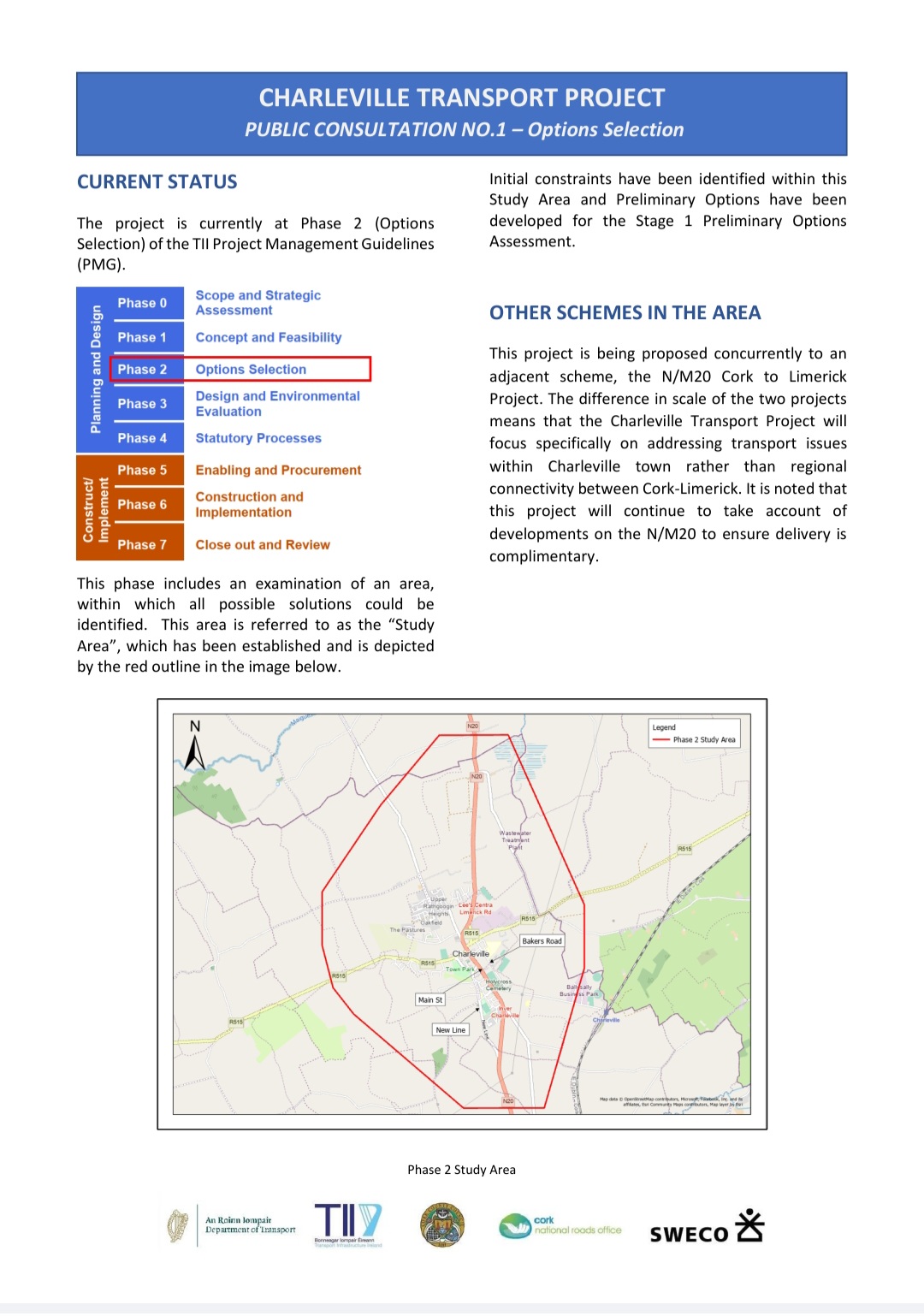
The study area for the scheme commences approximately 2.5km south of the junction between the N20 and R515 road in the townland of Knockardamrum and extends to approximately 3.1km north of the same junction in the townland of Creggane.
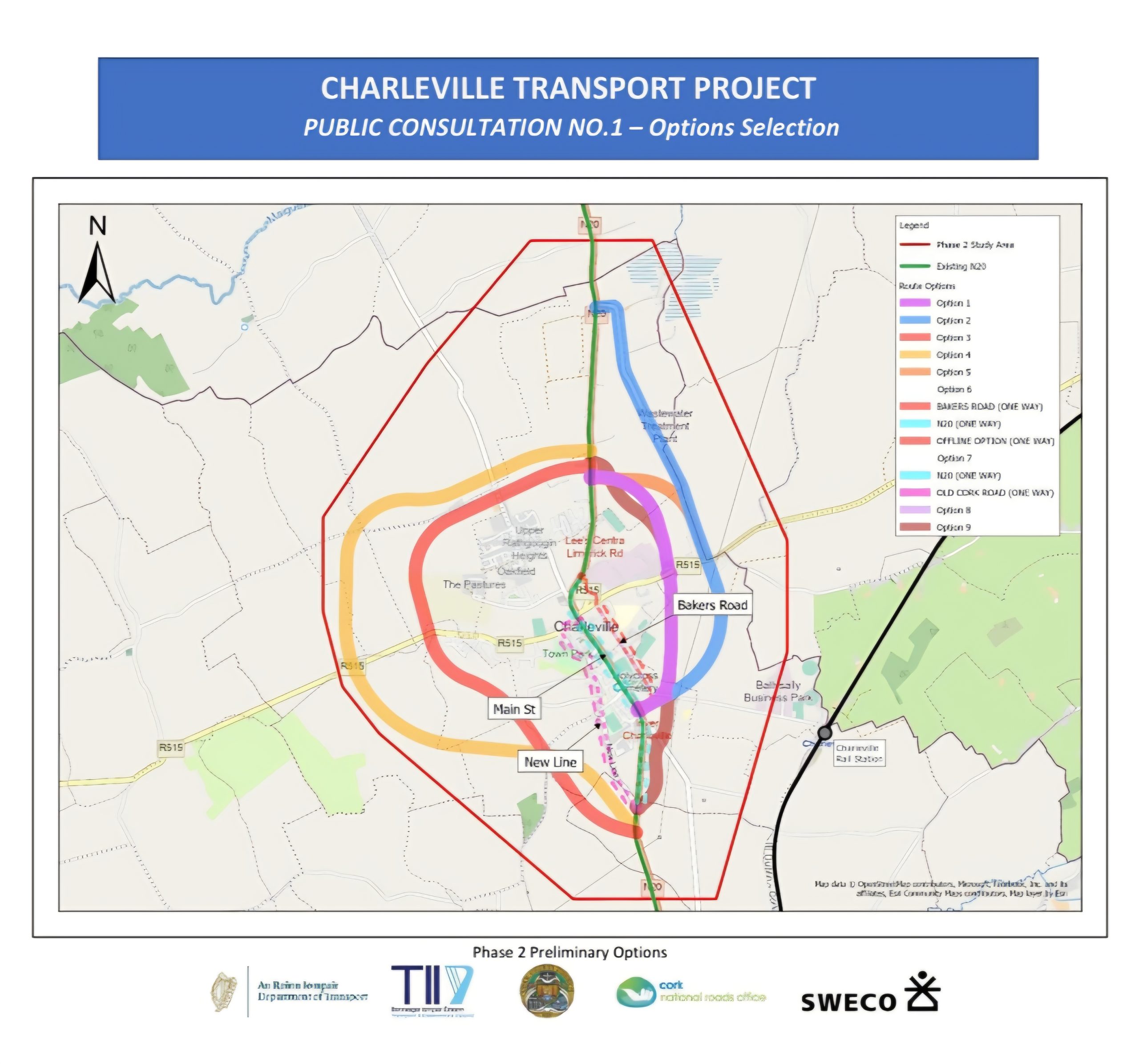
Phase 2 Preliminary Options
At present, initial constraints have been identified within the Study Area and Preliminary Options have been developed as following:
-
Do Nothing / Do Minimum – Comprises the existing situation plus any committed infrastructure that may impact the scheme
-
One-way systems – Introduction of one-way systems in the town, separating northbound and southbound traffic which currently utilises the N20 Main Street
-
Bakers Road – Improvements to Bakers Road including new corridor connecting the N20 to Bakers Road, with strategic traffic signposted to route via Bakers Road
-
Eastern Bypass – New bypass corridor to the east of Charleville town connecting the northern and southern approaches on the N20
-
Western Bypass – New bypass corridor to the west of Charleville town connecting the northern and southern approaches on the N20
Important Note: At this stage of the project, it is important to note that every effort will be made to avoid impacts on buildings including dwellings and farm infrastructure.
What Happens Next?
Feedback from this Public Consultation can be provided from 17th November to the 19th December 2025. See further details in the Public Consultation page of www.charlevilletp.ie
This will be taken into account as part of the Stage 1 Preliminary Options Assessment. The Project team will then assess the options against three criteria as following:
-
Engineering
-
Environment
-
Economy
The Stage 1 assessment will aim to shortlist the number of options that will be brought forward to Stage 2 Project Appraisal Matrix. Stage 2 will involve a Multi-Criteria Analysis (MCA) using the seven Transport Appraisal Framework (TAF) criteria:
-
Economy – Transport User Benefits and Wider Economic Impacts
-
Accessibility Impacts
-
Social Impacts
-
Land Use Impacts
-
Safety Impacts
-
Climate Change Impacts
-
Local Environmental Impacts
On completion of Stage 2, a Preferred Option will be selected as part of Stage 3 (Selection of Preferred Option) and displayed for information in summer 2026. The Preferred Option will be taken forward into Phase 3 (Design and Environmental Evaluation).
